|
|
South Channel | Point Wilson | Frankston Beach | Wilsons Prom
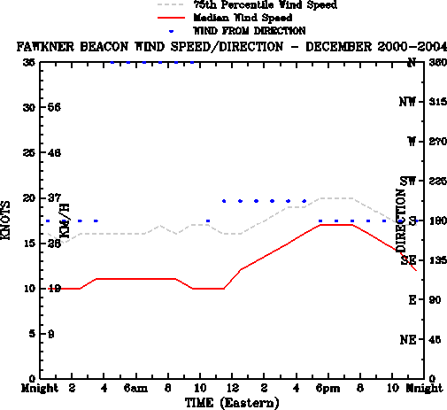
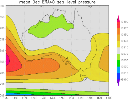
NB: Calculations are based upon 5-minute averages. Wind gusts will be up to 40% stronger. Data is from 2000-2004 (5 Years) The above graph shows the median wind speed (the speed at which half of the time the wind speed is faster, and half the time the speed is slower) in red, and the 75th Percentile wind speed (the wind speed that may be expected 1 in every 4 days) in grey. The most common wind direction is plotted with blue dots. Commentary: During the summer months, the prevailing synoptic pattern (see below) favours a light southerly breeze. Over Port Phillip, the land-sea interaction causes a typical cycle to overlay this pattern. Light winds around midnight are typically replaced by a gentle landbreeze between 4 and 5am, as the land cools more than the sea surface temperture of the northern bay and flows offshore. The land breeze remains until around 10-11am, when the sun warms the land temperature above that of the bay, and a light seabreeze develops from the south-southwest. This seabreeze strengthens through the afternoon, typically reaching around 15 knots by 4 to 5pm. Around this time the ocean breeze arrives, as the larger scale land warms above the temperature of the ocean, some 50-60km to the south, and draws air from Bass Strait up to the northern end of the bay. The arrival of the ocean breeze after 5pm raises the median wind speed to around 16-17 knots and swings the wind more southerly. The wind stays around this speed until 7-8pm, after which the sinking sun causes the land heating to reduce, thus weakening the combined sea/ocean breeze. After sunset (8-9pm), the cooling of the land steadily reduces the wind speed. It is worth noting that the above are mean conditions. The passing of cold fronts will often result in a moderate northerly wind followed by a swing to the south west, and an accompanying rise (sometimes only briefly) in wind speeds.
|
| | home | old page | contact | |
| Disclaimer: This page, its content and style, are the responsibility of the author and do not represent the views, policies or opinions of the The University of Melbourne. Whilst all care is taken, users are advised to check the original source of all data before use. |